
Thumb Drone Connects With Growers at the 2026 Northwest Michigan Orchard and Vineyard Show
January 2026 | Traverse City, Michigan — Thumb Drone LLC was proud to attend and exhibit at the 2026 Northwest Michigan Orchard and Vineyard Show held at the Grand Traverse Resort and Spa in Traverse City, Michigan. We shared our full fleet of professional agricultural drones and solutions with growers, farm managers, industry partners, and technology providers from across the region.
At our booth we engaged in meaningful, in depth discussions with cherry, apple, grape, blueberry, and other fruit growers, as well as wine makers, farm managers, row crop producers, manufacturers, and other exhibitors. Conversations focused on real world needs for precision agriculture technology, the capabilities of modern UAV systems, and how custom variable application rates and prescription spraying can deliver better outcomes in orchards, vineyards, and field crops.
Our team demonstrated the flexibility and power of our fleet, including high capacity spray drones with multiple payload configurations, granular spreaders, and advanced application planning tools. Attendees were able to see how our solutions can be tailored to their unique operations, whether they are a small family farm or a large commercial grower.
In addition to agricultural application services, we also connected with attendees on the broader role drones play across modern farm operations. Discussions included aerial marketing and promotional media, high resolution mapping for planning and documentation, and thermal imaging for crop health observation, drainage analysis, wildlife activity, and infrastructure monitoring. These conversations highlighted how farms of all sizes are using drone technology across multiple disciplines, not just application, to improve decision making, efficiency, and long term planning.
Thumb Drone extends our sincere thanks to MSU Extension and the organizers of the Northwest Michigan Orchard and Vineyard Show for hosting an informative, well run event. We also appreciate the hospitality of the Grand Traverse Resort and Spa and the opportunity to connect with the broader agricultural community in Traverse City, Michigan.
Growers and industry partners interested in learning more about our agricultural services or getting a custom quote are invited to visit our Agriculture Services page at thumbdrone.com/agriculture.
Thumb Drone Expands Agricultural Capabilities With Two DJI Agras T100 Spraying and Spreading Drones
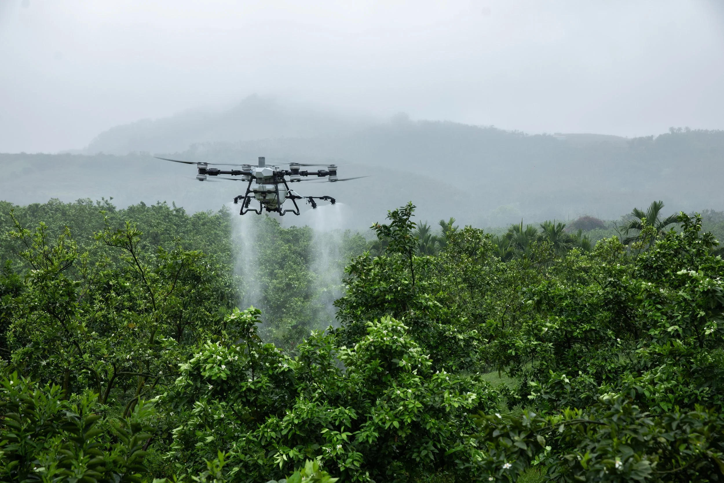
January 2026 | Davison, Michigan — Thumb Drone LLC is proud to announce the expansion of our agricultural operations with the addition of two DJI Agras T100 agricultural drones to our professional fleet. These new systems bring advanced spraying, misting, and granular spreading capabilities to support large scale growers and commercial agricultural clients throughout Michigan.
The DJI Agras T100 is DJI’s flagship agricultural platform designed for demanding crop protection and field care tasks. With a large 100 liter spray tank and modular payload options, the T100 delivers flexible, high capacity application performance for a wide variety of crop types and field conditions.
Multiple Payload Configurations for Specialty Applications
Each DJI Agras T100 in our fleet is equipped with a set of advanced spraying and spreading payloads to handle diverse agricultural needs:
Standard 2 nozzle spray frame for efficient liquid application across large fields and row crops.
4 nozzle mist kit for high volume and fine droplet output in dense canopy environments like orchards and vineyards. This setup increases flow rate and improves coverage under challenging conditions.
220 pound class granular spreader tank payload for dry material applications such as sulfur, fertilizer, seeding, soil amendments, and cover crop distribution.
The modular payload options allow Thumb Drone to match application method to the specific needs of each job. Whether providing broad acre crop protection, precision orchard misting, or efficient granular distribution, our Agras T100 systems provide the flexibility and performance our clients expect.
Enhanced Agricultural Productivity
The DJI Agras T100 features advanced flight systems including precision RTK positioning and comprehensive obstacle sensing for reliable operations in complex terrain. Its high output spray pumps and configurable nozzle setups deliver consistent application quality, while the large spreader system covers material distribution quickly and accurately.
These capabilities allow Thumb Drone to provide expanded service options to growers, agronomists, and land management professionals who need fast turnaround, precise application, and dependable results.
Commitment to Safe and Responsible Operations
All flights are conducted under strict FAA Part 107 certification and regulatory compliance. Thumb Drone pilots follow established safety protocols and best practices to ensure safe flights and professional service delivery on every job.
Looking Ahead
The addition of these two DJI Agras T100 drones strengthens Thumb Drone’s commitment to offering innovative aerial solutions that meet the evolving requirements of modern agriculture. For more information on agricultural services, project planning, or to discuss your upcoming season needs, get a custom quote at thumbdrone.com/agriculture.

Thumb Drone Expands Thermal Capabilities with DJI Matrice 4 Thermal

Thumb Drone LLC is proud to announce the addition of the DJI Matrice 4 Thermal to our growing fleet of professional unmanned aircraft systems. This expansion marks a significant step forward in our ability to provide advanced aerial data solutions, enhanced situational awareness, and mission-critical support services across Michigan and beyond.
The DJI Matrice 4 Thermal brings high-resolution thermal imaging alongside powerful visual sensors and enterprise-grade flight performance. This combination allows us to deliver actionable insights that are not visible to the naked eye, unlocking new capabilities for safety, inspection, assessment, and public service applications.
Expanded Search and Rescue and Public Assistance Capabilities
Thermal imaging plays a vital role in search and rescue operations, particularly during low-light conditions, nighttime operations, and challenging terrain. The Matrice 4 Thermal enables the rapid detection of human heat signatures, improving response times and expanding effective search areas. These capabilities are equally valuable for lost pet recovery, where thermal contrast can help locate animals moving through fields, wooded areas, or residential neighborhoods.
Thumb Drone LLC is available to assist municipalities, emergency response organizations, and community groups with aerial thermal support when time and accuracy matter most.
Solar, Infrastructure, and Utility Inspections
Thermal data is a powerful tool for identifying inefficiencies and potential failures in solar arrays, electrical infrastructure, and utilities. Using the Matrice 4 Thermal, we can detect hot spots, anomalies, and performance issues that traditional visual inspections may miss. This allows contractors, facility managers, and asset owners to address problems proactively while reducing downtime and inspection risk.
Our thermal inspection services support solar farms, commercial rooftops, utility corridors, and other critical infrastructure where safety, accuracy, and documentation are essential.
Residential and Commercial Building Assessments
The addition of a thermal payload also enhances our ability to support residential and commercial property assessments. Thermal imaging can help identify heat loss, insulation issues, moisture intrusion, and other conditions that may impact energy efficiency or structural integrity. These insights are especially valuable for property owners, real estate professionals, insurance documentation, and post-event evaluations.
All operations are conducted with strict adherence to FAA regulations, safety protocols, and best practices.
Advanced Technology Backed by Experience
With the integration of the DJI Matrice 4 Thermal, Thumb Drone LLC continues to invest in cutting-edge technology that delivers real value to clients. This aircraft complements our existing enterprise fleet and reinforces our commitment to providing reliable, data-driven aerial services.
Combined with our FAA Part 107 certification, insurance coverage, and nearly a decade of UAS experience, this new capability ensures our clients benefit from both advanced tools and proven operational expertise.
Integrated DJI AL1 SpotLight for Enhanced Night and Low-Light Operations
In addition to the thermal payload, our DJI Matrice 4 Thermal is equipped with the DJI AL1 SpotLight, a powerful, gimbal-synchronized illumination system designed to support night and low-light operations. The AL1 SpotLight provides focused, high-intensity lighting aligned with the camera’s field of view, allowing operators to visually confirm subjects detected by thermal imaging. This capability is especially valuable during search and rescue missions, lost pet recovery, public safety support, and infrastructure inspections where clear visual identification is critical. By combining thermal detection with precision lighting, Thumb Drone LLC can deliver safer operations, improved situational awareness, and more confident decision-making in challenging lighting conditions.
Looking Ahead
The addition of thermal imaging further expands the range of services Thumb Drone LLC can offer across industries including public safety, construction, energy, real estate, and municipal operations. As demand for accurate aerial data continues to grow, we remain focused on delivering professional, compliant, and results-driven drone solutions.
For more information about thermal drone services or to discuss a specific project, we invite you to contact us directly or explore our services on thumbdrone.com.
Thumb Drone LLC Receives FAA Waiver for Operations Over People and Moving Vehicles
Davison, MI – August 2025 – Thumb Drone LLC is proud to announce that we have officially received approval from the Federal Aviation Administration (FAA) for expanded operational capabilities under 14 CFR Part 107. Our new Certificate of Waiver (CoW) grants authorization for:
Operations over human beings (§107.39)
Operations over moving vehicles (§107.145)
This waiver, effective through mid-2029, is a significant milestone for our company and clients alike. It allows us to safely and legally capture aerial content in scenarios that were previously restricted, opening new opportunities for event coverage, marketing productions, construction documentation, and more.
What This Means for Our Clients
With this waiver, Thumb Drone LLC can provide expanded coverage and professional aerial photography and videography at:
Community festivals and parades where people are gathered.
Sporting events and outdoor performances with audiences present.
Commercial and industrial sites where vehicles and workers are active.
This approval demonstrates not only the FAA’s confidence in our safety protocols, equipment, and pilot training, but also our ongoing commitment to delivering high-quality results while adhering to the strictest safety standards.
Safety First, Always
While this waiver expands what we are able to do, safety remains our top priority. Thumb Drone LLC strictly follows all FAA special provisions, including pre-flight checklists, visual observer requirements, and coordination with event security teams when filming at venues with large crowds.
Looking Ahead
This waiver positions Thumb Drone LLC as one of the few aerial media companies in Michigan with FAA-approved authority for Operations Over People and Moving Vehicles. We are excited to bring this capability to upcoming projects across the state, from local community events to commercial productions.
For more information about how our FAA waiver can benefit your next project, or to schedule aerial coverage, please contact us at sales@thumbdrone.com or visit thumbdrone.com.

Aerial 360° Panorama Tour: Hillsdale College Summer 2025
A Homecoming From Above
As an alumnus of Hillsdale College and the founder of Thumb Drone LLC, returning to campus as a professional drone pilot was a full-circle moment. While I was in town for a commercial real estate project, I couldn’t pass up the opportunity to capture the campus from a whole new perspective—above.
The result is a self-initiated aerial tour of Hillsdale College, featuring a series of high-resolution 360° panoramas taken during the summer of 2025. These interactive drone photos offer a fresh way for prospective students, alumni, and curious visitors to explore the college’s architecture, green spaces, athletic facilities, and recent developments.
All of the panoramas are available on our Google Maps profile, but you can also view many of them directly on this page below—no extra clicks required.

Explore the Hillsdale College Campus from Above Using Drones
The tour below features more than a dozen key campus locations—from iconic landmarks to newer facilities that have transformed the student experience in recent years. Scroll through the embedded panoramas or click the links to open each location in Google Maps.
High Altitude View of Central Hall – A sweeping aerial overview of campus from high above, capturing Central Hall, nearby dorms, and even current construction and expansion projects.
Hayden Park – A new addition since my graduation—this outdoor athletic complex includes a track, trails, and green space for cross-country and recreation.
Margot V. Biermann Athletic Center – Hillsdale’s impressive indoor track facility and training space—also home to a 22-foot-tall poster of me from my throwing days.
TFO Partners Field & Hill Stadium – The recently redeveloped home of Charger Baseball, featuring upgraded seating, dugouts, and a clean field layout visible from above.
Muddy Waters Stadium – A classic Hillsdale venue, home to Charger Football. The aerial view includes the historic track oval and surrounding practice fields.
Roche Sports Complex – Captured from the hammer ring—a personal favorite spot—this panorama showcases the entrance, outdoor training areas, and surrounding campus scenery.
Greek Life Houses – Aerial views of Delta Sigma Phi, Sigma Chi, Alpha Tau Omega, and Kappa Kappa Gamma offer a look at fraternity and sorority life on campus.
Lane Hall, Delp Hall, and Central Hall – Three pillars of the student experience—these residence and academic buildings are central to both daily life and Hillsdale’s identity.
Slayton Arboretum – A quiet natural retreat located just off campus. The arboretum is filled with walking paths, bridges, gardens, and now—its own aerial panorama.
The Suites – This upperclassmen dorm was brand new when I arrived as a freshman in 2005. It remains one of the most modern residence options on campus.
Dow Hotel and Conference Center – Popular with visiting families, speakers, and conference attendees, this building is a cornerstone of Hillsdale’s hospitality presence.
Searle Center – One of the college’s largest indoor venues, used for commencement, conferences, and major student events.
Simpson Hall – A well-known residence hall that’s part of many students’ freshman-year experience, now shown from a unique elevated perspective.
Phi Sigma Epsilon Alumni Pavilion – A new scenic gathering space honoring Hillsdale's Phi Sigma Epsilon alumni, now featured from inside in crisp 360° detail.
See Hillsdale College from Above
Whether you're exploring Hillsdale College for the first time or revisiting it years later, this virtual drone tour offers a fresh perspective on a place defined by tradition, growth, and beauty. From the steps of Central Hall to the winding paths of the Arboretum, these 360° aerial views bring the campus to life in a way few have seen before.
Designed for prospective students, alumni, and anyone curious about campus life, this drone-powered virtual tour highlights Hillsdale’s most iconic landmarks, updated athletic facilities, and student housing—all from the sky.
If you’ve enjoyed this experience, feel free to share it with others or dive deeper into the panoramas above. It’s a whole new way to see Hillsdale—without setting foot on campus.
Why Aerial Tours Make Campus Visits Better
Looking to promote your own school, community, or organization? Aerial media can do more than capture beauty—it tells a story from above. If you're interested in bringing this kind of virtual experience to your institution, I’d love to help.
Contact: sales@thumbdrone.com
More Projects: ThumbDrone.com